Lifelines Project: Char Valley
|
2 Project Detail
2.1 The Problem - The problem was outlined in 1.1. and some related scientific evidence appears in the appendix. The intention is to keep collecting this data and making it accessible online so that people with different interests can follow links to relevant research. The LIfelines Project has separated out what is being called ‘insect armageddon’ (although it can only be understood with reference to other issues like climate change, land management techniques, etc.) for several reasons, which are considered below. But the Project will always make clear that the decline in insect populations is inextricably linked to other, systemic changes and problems. As the Project shows how insect loss is also linked to climate change and habitat destruction, it could, over time, expand to record other sustainable land management practices (see 2.4 below). By targeting insect loss it can also target chemical pesticides: i.e. herbicides, fungicides and insecticides. All three are included because all three have been shown to directly affect insects. Insecticides kill them. Fungicides and herbicides kill the plants and fungi in and on which they live and damage insect digestion, reproduction and other systems. 2.2 The Objective As outlined in 1.2, the primary objective is to identify, map and try to extend areas of land where chemical pesticides are not used. But the second, core objective is to engage local gardeners, children, families, farmers and others. This is why the Project has chosen to focus on insect loss:
2.3 The Method- Initially the project will have three stages: Step 1 is to identify the plots of land – gardens, fields, hedges, streams, ponds, woodland and farmland – in the Char Valley that are managed without chemical pesticides. (All that is required is for the owner to say so – no checks or audits will be made.) The Project started with the River Char Catchment but has already added neighbouring land (for example in Stanton St Gabriel) so as to draw in local landowners who are known to farm without chemical pesticides. Step 2 is to record these plots, however small – and their traditional names – on an interactive, community map and database of the Char Valley. This will be publicly accessible via the internet. Users will be able to see which areas are covered. As people tell us about land that is pesticide-free, their gardens and fields change colour on the community map. Step 3 is to invite residents, farmers and landowners in the Char Valley to expand or join-up these areas to create pesticide-free corridors (lifelines). (Where a farm cannot stop using chemicals, it may be possible to do so in certain fields, along the riverbank, etc.) The map will be continually developed to show the progress of the project as it happens. >>> Continue to: 2.4 - Later Project Development (<<< back to Outline Proposal) 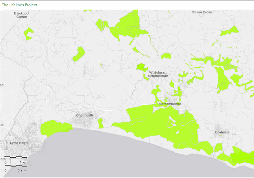
|
